Lake Candlewood
Reservoir in Connecticut · 5,263 acres · near Candlewood Point, Candlewood Shores, Danbury, Knollcrest


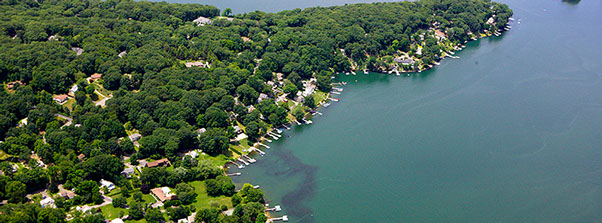

Candlewood Lake is a man-made reservoir in Fairfield and Litchfield counties in western Connecticut. It is the largest lake in the state. The Candlewood Lake Authority lists it at 5,420 acres, about 11 miles long and up to about 2 miles wide, with roughly 65 miles of shoreline. Its average depth is 29.3 feet and its maximum depth is about 85 feet. Its shoreline lies in Brookfield, New Fairfield, New Milford, Sherman and the City of Danbury. Connecticut Light and Power approved the project in 1926 as the first large-scale pumped-storage operation in the United States. The lake was created by damming the Rocky River and flooding the valleys, and the work was completed on September 29, 1928. The village of Jerusalem was submerged. FirstLight Power owns and operates the lake as a hydropower facility licensed by the Federal Energy Regulatory Commission. Water is pumped up from the Housatonic River.
The Connecticut Department of Energy and Environmental Protection (DEEP) runs two public launches on the lake: Squantz Cove on Route 39 in New Fairfield and Lattins Cove in Danbury. Each holds up to 100 vehicles and closes when full. Residents of the five shoreline municipalities can also use town launches. Boats must be under 26 feet long unless they carry an exemption sticker. The speed limit is 45 mph by day and 25 mph at night. Boats must travel at slow/no-wake speed within 100 feet of shore, and personal watercraft within 200 feet. Boaters must inspect their vessels for aquatic invasive species. DEEP and the Candlewood Lake Authority Marine Patrol patrol the lake. During boating season the water level ranges from 427 to 429.5 feet above sea level.
Eelgrass and Eurasian milfoil grow in the shallower areas. The lake is usually lowered by about 10 feet in winter to help control the weeds.
Boating rules
- Boats must be under 26 feet in length unless they display a valid exemption sticker ($75 fine) source
- Daytime speed limit 45 mph; nighttime speed limit 25 mph (enforced by radar) source
- Slow/no-wake within 100 feet of shore, docks, swim areas, floats or anchored or moored vessels; 200 feet for personal watercraft source
- Vessels must be inspected and cleaned of vegetation and aquatic nuisance species before transport ($95 fine per violation) source
- Connecticut Aquatic Invasive Species (AIS) Stamp required, bought separately from vessel registration since Oct 1, 2024 source
- State launches have a 100-vehicle capacity and close when full source
Rules change; check with the agency or town before you go.
Launches
- Candlewood Lake (Lattins Cove) Boat Launch · Boat ramp · near Danbury · free
- Candlewood Lake (Squantz Cove) Boat Launch · Boat ramp · near New Fairfield · free
Community
Where people who fish, boat and paddle Lake Candlewood talk about it. Lake associations, clubs and local groups will be added as we find them.
- Candlewood Lake Authority Association
- Candlewood Lake Authority (Facebook) Facebook
- What Boaters Need to Know - Candlewood Lake Authority (notices, water levels) Agency
- Squantz Cove State Boat Launch - CT DEEP Agency
- Search Reddit: r/Connecticut Reddit
- Search all of Reddit for Lake Candlewood, Connecticut Reddit
Sources
- Fast Facts & Map - Candlewood Lake Authority
- What Boaters Need to Know - Candlewood Lake Authority
- Parks & Launches - Candlewood Lake Authority
- Squantz Cove State Boat Launch - CT DEEP
- Candlewood Lake - Wikipedia
Researched October 13, 2026 from the sources above. Written content CC BY 4.0. Something wrong? Corrections are welcome.
Wikidata: Q5032008